
Italiani nel Mondo
I confini sono linee tracciate sulle mappe e sulla sabbia, non sono la storia- Borders are lines on maps and sand, they are not history

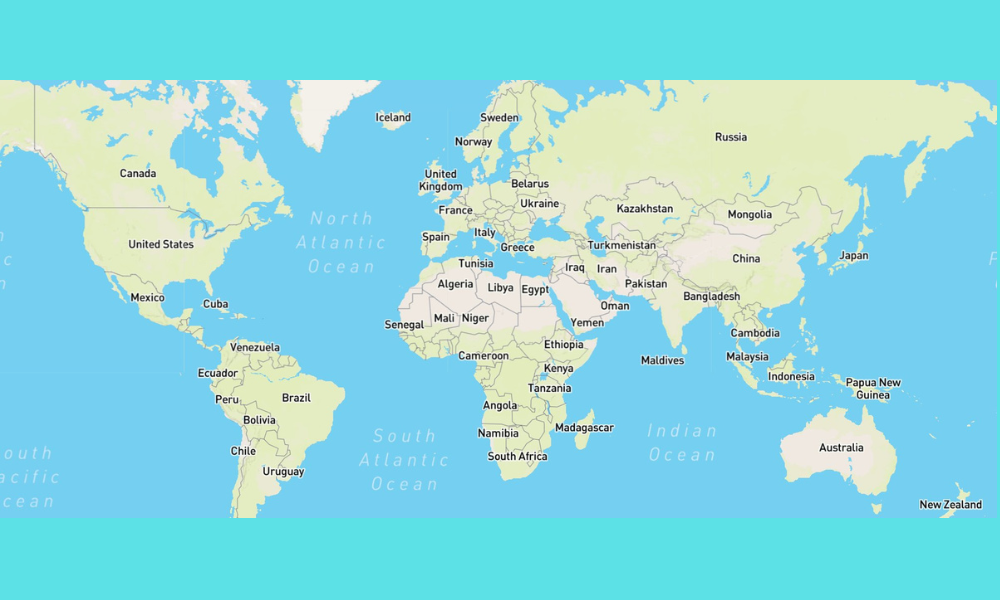


I confini sono linee tracciate sulle mappe e sulla sabbia, non sono la storia
Nel 2019 il governo austriaco appena eletto ha offerto la possibilità di ottenere la cittadinanza austriaca alle persone di lingua tedesca e ladina residenti nella regione italiana dell’Alto Adige, nota anche come Südtirol quando l’area faceva parte dell’Austria prima della Grande Guerra.
L’incidente tra Italia e Austria può sembrare banale ad alcuni, ma ha dimostrato che in Europa ci sono ancora persone che sognano il ritorno delle loro regioni “perdute”; le guerre balcaniche degli anni ’90 e il perdurare dello stato di guerra tra Russia e Ucraina dimostrano chiaramente che questo potenziale esiste ancora nel “Vecchio Continente”.
Questo incidente diplomatico, che ha suscitato l’ira del governo italiano, ha ricordato che in molti paesi europei esistono regioni ancora contese tra uno o più Stati, che nel corso dei secoli sono state spesso motivo di guerra. Tuttavia, questo episodio dovrebbe anche farci comprendere che, in molti casi, i confini nazionali spesso non sono il risultato di sviluppi storici antichi, ma, in non pochi casi, sono addirittura imposizioni da parte delle potenze coloniali ufficiali – prevalentemente europee – in Africa, Medio Oriente e Asia, che hanno tracciato linee sulle mappe per evitare conflitti armati tra loro.
Quando osserviamo le mappe che “definiscono” i confini dei paesi moderni in tutto il mondo, molti dei quali spesso non esistevano prima della Seconda Guerra Mondiale, pochissimi di noi comprendono che spesso essi non seguono chiare divisioni geografiche.
Infatti, basta guardare le mappe dell’Africa, del Medio Oriente e dell’Asia per vedere confini che attraversano foreste, giungle o deserti, spesso dividendo territori tribali ancestrali tra “nuovi” paesi, creando gravi problemi per la sicurezza dei confini nazionali e fornendo spesso anche a queste tribù i mezzi per contrabbandare droghe illegali e altri prodotti tra i paesi.
Purtroppo, molti di questi confini sono stati tracciati da stranieri per ragioni che non avevano nulla a che vedere con gli interessi delle popolazioni locali.
Ad esempio, con la creazione delle Nazioni Unite dopo la Seconda Guerra Mondiale, sono stati creati paesi come il Vietnam del Nord e del Sud, la Corea del Nord e del Sud e persino Israele per cercare di evitare conflitti tra gruppi, ma tragicamente, essi sono poi diventati la causa di conflitti tra le superpotenze emergenti, gli Stati Uniti e l’Unione Sovietica.
Questi nuovi «confini nazionali» raramente tenevano conto dei confini geografici naturali dei nuovi paesi e, soprattutto, dei gruppi etnici e delle tribù presenti in essi, il che ha poi portato ai conflitti di cui sentiamo parlare regolarmente sui giornali e nei telegiornali.
Infatti, la creazione di quello che oggi è il Ruanda ha diviso i territori tribali, conferendo a una tribù il predominio sulle altre mentre i belgi controllavano ancora il paese; queste tensioni intertribali sono poi esplose dopo la partenza degli ex colonialisti e sono state la causa principale degli orribili massacri a cui abbiamo assistito in quel paese nel 1994.
Ma c’era una ex potenza coloniale, l’Impero britannico, che contava milioni di soldati provenienti dalle proprie colonie, in particolare dal subcontinente indiano, a combattere per essa; che comprese che la Seconda guerra mondiale aveva insegnato ai propri sudditi coloniali che era possibile lottare per la propria libertà. La sua soluzione fu quella di liberare le ex colonie e invitarle ad aderire al nuovo Commonwealth britannico, il che permise al Regno Unito di mantenere la propria influenza economica in quelle regioni.
Ma in un caso, questa concezione apparentemente di larghe vedute non fu rispettata quando, nelle ultime settimane del dominio britannico, l’ex subcontinente indiano, con la sua storia e le sue culture antiche e gloriose, fu diviso in due paesi: la Repubblica dell’India, a maggioranza indù, e la Repubblica del Pakistan, a maggioranza musulmana, a sua volta divisa in due parti, il Pakistan occidentale e quello orientale.
E l’aspetto più triste di questa partizione fu che fu opera di un burocrate che tracciò i confini dei due nuovi paesi senza visitare le aree interessate, il che significò che i nuovi confini attraversavano persino villaggi e città, rendendo le persone “stranieri” nei luoghi in cui le loro famiglie avevano vissuto per molte generazioni e trasformando i loro ex vicini in “nemici” …
A seguito di questa disastrosa decisione, circa quindici milioni di indù, sikh e musulmani furono costretti ad abbandonare le loro case ancestrali, dove erano diventati “stranieri”, per cercare rifugio nell’“altro Paese”. Si ritiene oggi che circa due milioni di persone di tutte le religioni siano state massacrate nelle rivolte che accompagnarono la Partizione.
E l’artefice di questa Partizione non si aspettava certamente che essa avrebbe portato a quattro guerre tra India e Pakistan, né alla nascita di un altro Paese, il Bangladesh, dal Pakistan orientale. E durante questi decenni di conflitti entrambi i Paesi sono diventati potenze nucleari e si sono verificati persino numerosi atti di terrorismo da entrambe le parti che hanno compromesso la stabilità politica della regione.
Il simbolo di questi conflitti è il Kashmir, che è stato diviso tra India e Pakistan. Entrambe le parti del confine hanno subito periodi di stato di emergenza a causa dei «combattenti per la libertà» presenti in questi territori, che a loro volta si dividono in tre categorie: coloro che vogliono un Kashmir «indiano», un Kashmir «pakistano» e un Kashmir libero e indipendente.
Infatti, il simbolo quotidiano di questa rivalità, nata dalla Partizione del subcontinente indiano, è la cerimonia che si svolge ogni giorno al valico di frontiera di Wagah, dove i soldati di entrambe le parti sfruttano la cerimonia per «dimostrare» la propria superiorità sui rivali, tra le acclamazioni dei propri sostenitori, come si vede nel filmato qui sotto.
Cerimonia al confine di Wagah
A questo punto immagino che alcuni lettori si chiederanno perché un tale contesto sia importante. Il motivo è semplice.
Quando parliamo di flussi migratori, legali o illegali che siano, dobbiamo conoscere la storia di una regione perché è essenziale per comprendere le condizioni che costringono ogni anno innumerevoli migranti a rischiare la vita alla ricerca di una vita migliore in un altro paese.
A peggiorare le cose, l’esperienza coloniale britannica ha creato un altro concetto che non è mai scomparso dalla mente dei parlamentari delle ex potenze coloniali: l’idea che le popolazioni autoctone fossero il «fardello dell’uomo bianco», che ancora oggi caratterizza l’atteggiamento di troppe persone in Europa nei confronti di questi ex sudditi. E la prova di ciò deriva dalla continua ingerenza degli ex colonialisti nei loro ex territori, non solo da parte degli inglesi, ma anche della Francia e, in non pochi casi, persino degli americani nei paesi conquistati durante la guerra ispano-americana del 1898, che portò paesi come Cuba e le Filippine nella sfera di interesse degli Stati Uniti.
Quindi, quando vediamo i nuovi migranti arrivare in Europa e in altri paesi, non dovremmo porci la banale domanda: «Perché queste persone non richiedono visti regolari?», ma piuttosto dovremmo chiederci: «Cosa è successo nei loro luoghi di origine per spingerli a rischiare la vita?», perché, fin troppo spesso, le vere ragioni della migrazione, tra cui l’instabilità politica e persino le catastrofi naturali, non vengono riportate dalla stampa estera.
E se vogliamo davvero risolvere i problemi causati da queste ondate di immigrati, dobbiamo partire dal comprendere che in molti casi le condizioni che hanno provocato questa migrazione sono state determinate da interferenze straniere e non da circostanze locali…
Borders are lines on maps and sand, they are not history
In 2019 the newly elected Austrian government offered the possibility of Austrian citizenship to German and Ladino speaking people in Italy’s Alto Adige Region, also known as Süd Tirol when the area was part of Austria before the Great War.
The incident between Italy and Austria may seem trivial to some, but it showed that there are still those in Europe who dream about the return of their “lost” regions and the Balkan Wars of the 1990s and the continuing state of war between Russia and the Ukraine clearly show that this potential still exists in the “Old Continent”.
This diplomatic incident, that raised the ire of Italy’s government, was a reminder than in many European countries there are regions that are still contested between one or more countries which were often the reasons for war over the centuries. However, this incident should also make us realize that in many cases, national borders are often not ancient developments, and in not a few cases, even impositions by formal colonial powers in Africa, overwhelmingly European, in Africa, the Middle East and Asia, that used lines drawn on maps to avoid armed conflicts between themselves.
When we look at maps that “define” the borders of modern countries around the world, many of which often never existed before the Second World War, very few of us understand that they often do not follow clear geographical divisions.
In fact, you only have to look at the maps of Africa, the Middle East and Asia to see borders running through forests, jungles, or deserts, often dividing ancestral tribal lands between “new” countries, creating major problems for the security of national borders, and are also often providing the means for smuggling illegal drugs and other products between countries by these tribes.
Unfortunately, many of these borders were drawn by foreigners for reasons that had nothing to do with the interest of the local populations.
For example, with the creation of the United Nations after WW2, countries such as North and South Vietnam, North and South Korea and even Israel were created to try and avoid conflicts between groups, but tragically, they then became the cause of conflict between the emerging superpowers, the United States and the Soviet Union.
These new “national borders” rarely considered the natural geographic boundaries of the new countries, and above all, the ethnic groups and tribes in these countries, which then led to the conflicts we see regularly in the newspapers and TV news reports.
Indeed, the creation of what is now Ruanda split tribal territories, giving one tribe dominance over the others while the Belgians still controlled the country, and these intertribal tensions boiled over after the departure of the former colonialists and were the primary basis of the horrific massacres we saw in that country in 1994.
But there was one former colonial power, the British Empire, which had millions of soldiers from their colonies, particularly the Indian subcontinent, fighting for them, that understood that WW2 had taught their colonial subjects that it was possible to fight for their freedom. Their solution was to free their former colonies and to invite them to join the new British Commonwealth which allowed the UK to keep its economic influence in those regions.
But in one case, this apparently openminded notion was not respected when, in the final weeks of British rule, the former Indian Subcontinent with its ancient and glorious history and Cultures, was divide into two countries, the Hindu majority Republic of India and the Moslem majority Republic of Pakistan, itself divided into two parts, West and East Pakistan.
And the saddest thing about this Partition was that it was done by a bureaucrat who drew the borders of the two new countries without visiting the areas affected, which meant the new borders even ran through villages and towns, making people “foreigners” of places where their families had lived for many generations, and turning their former neighbours into “enemies” …
As a result of this disastrous decision, about fifteen million Hindus, Sikhs and Moslems were forced to leave their ancestral homes where they had become “outsiders” to seek refuge in the “other country”. It is now believed that about two million people, of all religions, were massacred in the riots that accompanied the Partition.
And the creator of this Partition certainly did not expect that it would result in four wars between India and Pakistan, and the creation of another country, Bangladesh, from East Pakistan. And during these decades of conflicts both countries have become nuclear powers and there have even been numerous acts of terrorism by both sides which have affected the political stability of the region.
The symbol of these conflicts is Kashmir which was divided between India and Pakistan. Boths sides of the border have suffered periods of emergency powers due to the “freedom fighters” in these territories which themselves are divided into three categories, those who want ad “Indian” Kashmir, a “Pakistani” Kashmir and a free and independent Kashmir.
In fact, the daily symbol of this rivalry created by the Partition of the Indian sub-continent is the daily ceremony at the Wagah Border point where the soldiers of both sides use the ceremony to “prove” their superiority over their rivals, to the cheers of their followers, as we see in the film clip below.
Wagah Border ceremony
At this point I can imagine that some readers will wonder why such a background is important. The reason is simple.
When we talk about flows of Migration, legal or illegal, we must know the history of a region because it is essential for understanding the conditions that force countless migrants to risk their lives every year to seek a better life in another country.
Worse still, the British Colonial experience created another concept that has never disappeared from the minds of the parliamentarians in the former colonial powers, the concept that the native populations were the “White Man’s Burden”, which still is the attitude of too many people in Europe towards these former subjects. And the proof of this comes from the continual interference of the former colonialists in their former territories, not just the British, but also France, and in not a few cases, even the Americans in the countries conquered during the Spanish American War of 1898 which brought countries such as Cuba and the Philippines into America’s sphere of interest.
So, when we see the new migrants reach Europe and other countries, we should not ask ourselves the banal question of “Why don’t these people apply for legal visas?”, but rather, we should ask “What happened in their places of origin for them to risk their lives?”, because, all too often the real reasons for the Migration, including policial instability and even natural disasters, have not been reported in the foreign Press.
And if we really want to solve the problems caused by these waves of immigrants, we must start with understanding that in many cases the conditions that caused this migration was due to foreign interference and not local conditions…


